
Maxwell Falls hike: routes, distance and difficulty
Day use only; no camping, fires or shooting. Current conditions
Which Maxwell Falls hike is right for you?
One waterfall, one main trail, several ways to hike it. The trail runs about 2.25 miles between two trailheads, and the falls sit much closer to the upper end. A side loop over the cliffs adds views and lets you turn either end into a loop.
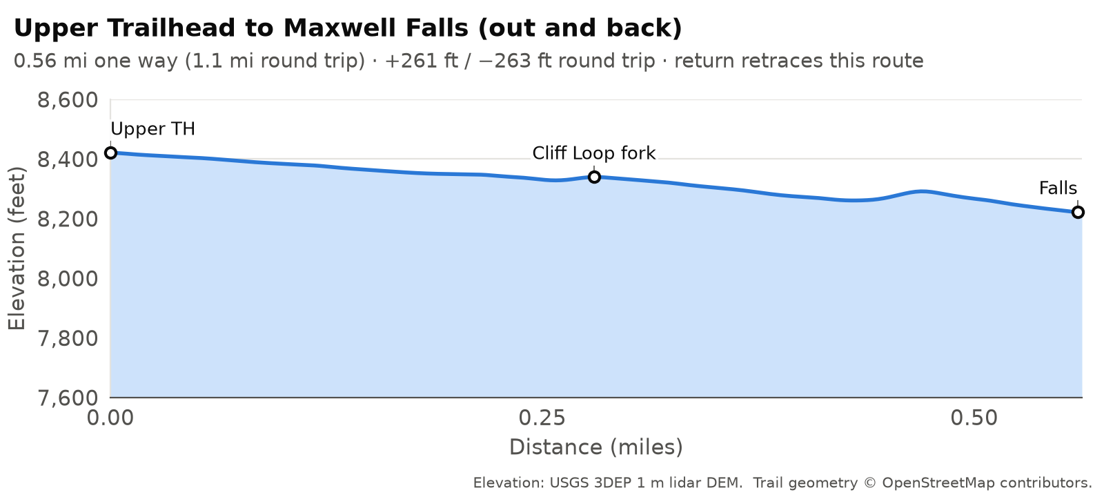
- Under an hour: the upper trail to the falls, about 1.1 miles round trip. Downhill in, uphill out.
- About 2 hours along the creek: the lower trail to the falls, about 3.4 miles round trip with roughly 850 ft of climbing.
- Views as well as the falls: the Cliff Loop, about 2.4 miles from the upper trailhead or a 4.5-mile loop from the lower trailhead.
- The whole trail one way: a two-car shuttle between trailheads, about 2.25 miles.
Map © OpenStreetMap contributors. Trail signs are few: photograph the trailhead map before you start.
Route comparison
| Route | Distance | Climb | Est. time | Difficulty | Start |
|---|---|---|---|---|---|
| Upper trail to the falls (out and back) | 0.6 mi one way / 1.1 mi RT | ~260 ft, all on the return | 30–45 min | Easy, with a steady climb back out | Upper trailhead |
| Lower trail to the falls (out and back) | 1.7 mi one way / 3.4 mi RT | ~850 ft RT | 1.5–2 h | Moderate | Lower trailhead |
| Lower trailhead loop with the Cliff Loop | 4.5 mi loop | ~1,150 ft | 2–2.5 h | Moderate, short steep pitches | Lower trailhead |
| Cliff Loop from the upper trailhead | 2.4 mi loop | ~580 ft | 1–1.5 h | Moderate, short steep pitches | Upper trailhead |
| Full trail, one way (two-car shuttle) | 2.25 mi one way | Uphill direction ~890 ft; downhill direction ~240 ft | 1–1.5 h | Moderate | Either trailhead, car at the other |
| Road between the lots (not recommended on foot) | 2.8 mi one way | ~710 ft walking up from the lower lot | About 1 h, in traffic | Not a hiking route | See the road warning |
Distances follow OpenStreetMap trail lines (© OpenStreetMap contributors); climb comes from USGS 3DEP 1 m lidar and is good to about 10–15%. Times are moving time plus a short stop at the falls. How we measured
The trail system in brief
Besides the official Forest Service trails, the Maxwell Falls area is crisscrossed by other trails, old roads and junctions that nobody has officially mapped or signed. Wrong turns are easy. Know where you’re going before you start, and put the trails on your phone or GPS before you leave home so they work without a signal. Our GPX tracks and printable map are one way to do that. Another is the free COTREX app, Colorado’s official state trail map, which the Forest Service posts at the trailhead kiosks; save the area for offline use before you go.
The Forest Service manages two signed trails here, plus a longer one that starts nearby:
- Maxwell Falls Trail (#39): the main trail, about 2.25 miles from the lower trailhead on Brook Forest Road to the upper trailhead off Black Mountain Drive. It passes right by the falls.
- Maxwell Falls Loop, known locally as the Cliff Loop (#39.1): about 1.15 miles over a rocky ridge between two junctions on the main trail, one just above the footbridge and one just above the falls. Some apps call this area the “Maxwell Bluffs.”
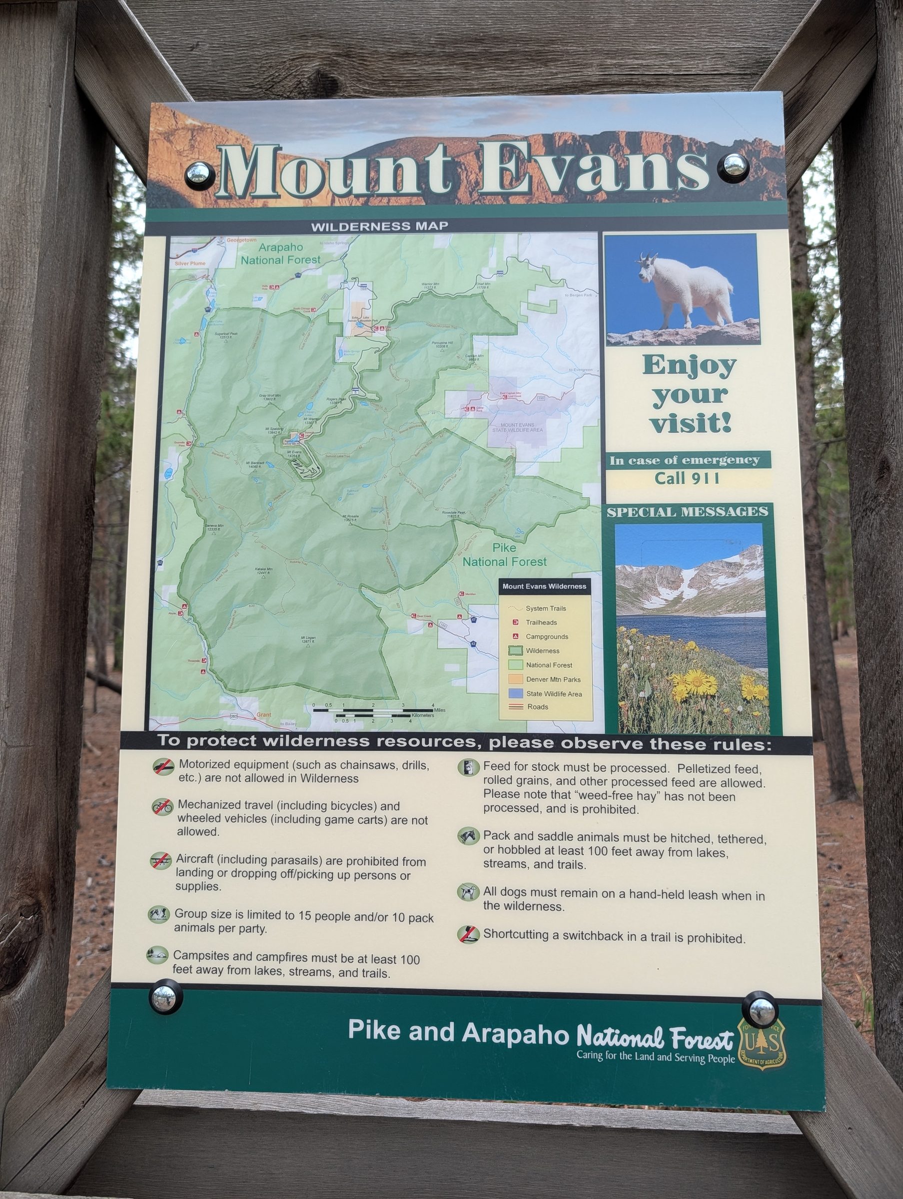
- Cub Creek Trail (#40): a longer trail from a separate trailhead nearby, heading west toward the Mount Evans Wilderness boundary. The Forest Service lists it as open, and its first stretch falls under the same day-use order as Maxwell Falls. The “Cub Creek Trail No. 40” post (September 2026) allows hikers, horses and bicycles, with “No e-bikes” and no motor vehicles, and a Mount Evans Wilderness information board stands at the trailhead. Bikes aren’t allowed inside the wilderness.
A note on trail numbers
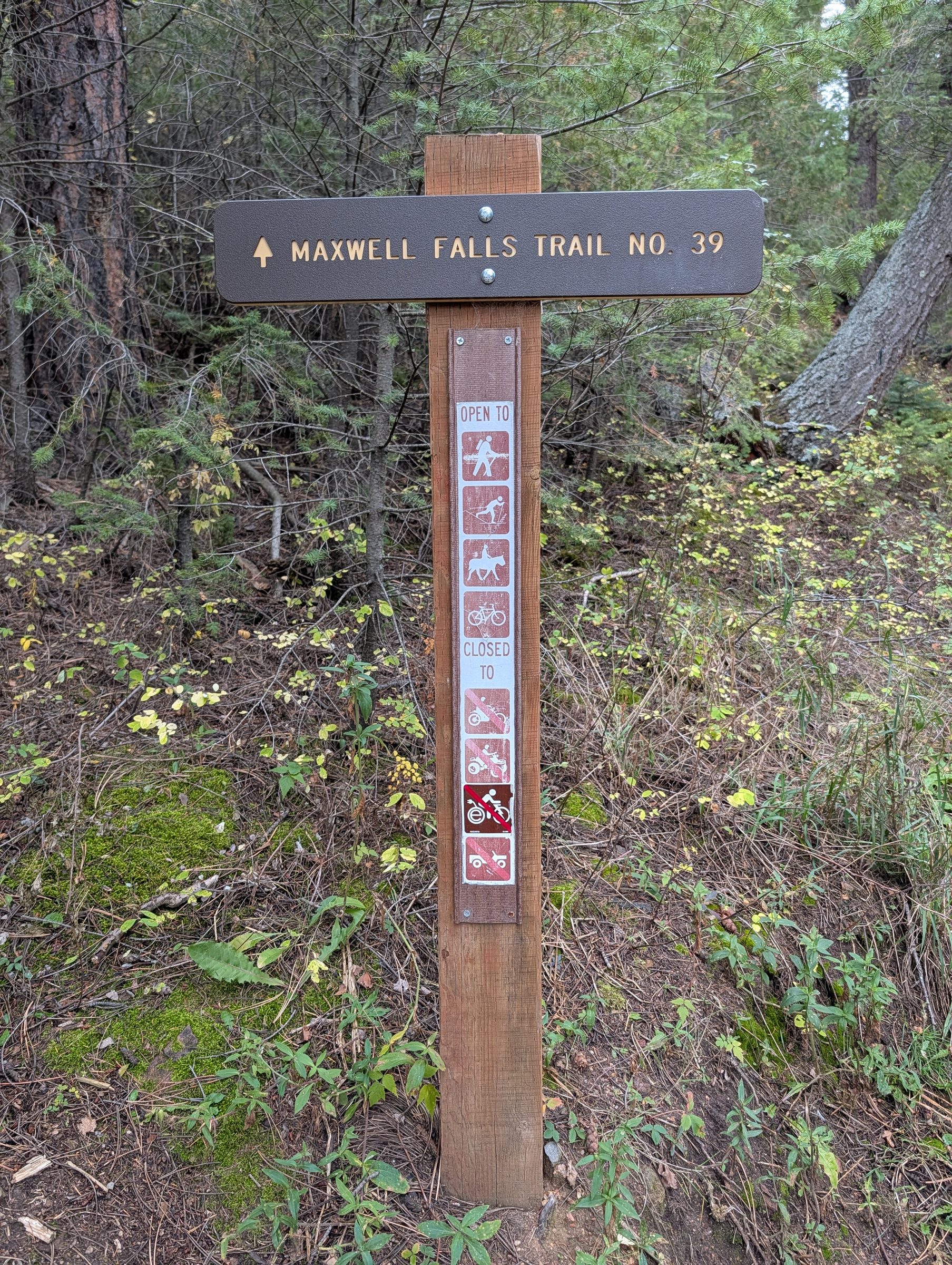
The main trail is No. 39, and the Cliff Loop is No. 39.1.
The brown trail posts at both the lower and the upper trailhead read “Maxwell Falls Trail No. 39” (posted at the trailhead in September 2026). The Forest Service’s own trail GIS data (USFS National Forest System Trails dataset) agrees, listing “Maxwell Falls” as trail 39 and “Maxwell Falls Loop” as 39.1, and so do the USGS trail data behind The National Map topo maps, the state’s COTREX trail database and the Colorado Mountain Club route page.
You’ll still see #111 in places. The Forest Service’s older web pages for the lower and upper trails call it #111, and so did the old wooden post at the lower trailhead, which read “Maxwell Falls Trail No. 111” when we photographed it in April 2017. That post has since been replaced. It’s the same trail either way.
If you’re reporting a problem or calling for help, give the trail name and the trailhead as well as the number.
Old roads cross the area too. One climbs from near the lower lot to a saddle on the trail, and another connects near the upper end. Both are old four-wheel-drive alignments, not the signed trail, and they account for a lot of wrong turns. Stay on the signed trail.
Elevation profiles
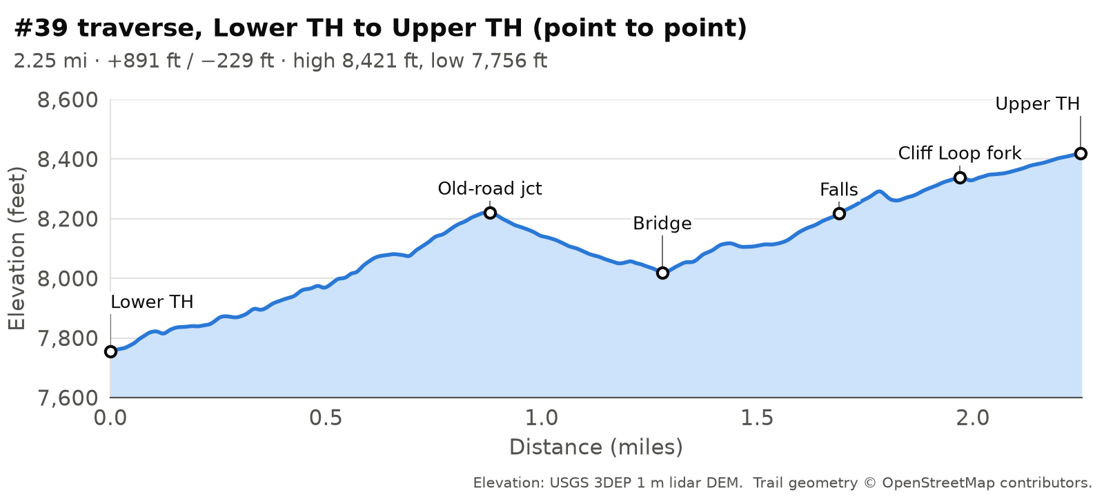
All three charts share the same vertical scale (7,600 to 8,600 ft), so you can compare them directly. The out-and-back charts show the way in; the way back is the same trail in reverse.
Upper trailhead to the falls
Lower trailhead to the falls
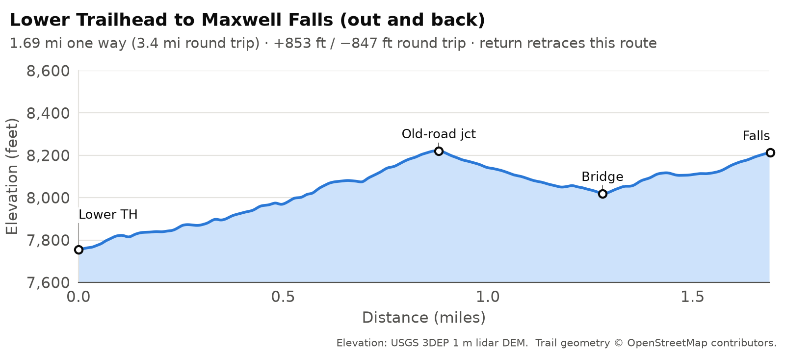
People expect the lower route to be a steady climb up the creek. It isn’t. It climbs about 460 ft to a saddle, drops about 200 ft to a footbridge over Maxwell Creek, then climbs about 200 ft to the falls, so you climb on the way back too.
Full trail, lower to upper
How hard is it?
The Forest Service calls Maxwell Falls “one of the easiest trails on the district,” and for a Colorado mountain trail that’s fair. There’s no exposure, no scrambling and not much distance. If you don’t hike much, though, a few things can catch you out.
The trail runs between about 7,750 and 8,420 ft, and visitors from lower elevations feel it. It’s steep in short bursts: the steepest stretches reach about 25% on the main trail and about 28% on the Cliff Loop, measured over 100 ft, on footing of dirt, roots, rock and loose gravel. The upper route saves all its climbing for the walk back to the car, which is where families tend to get surprised. The lower route climbs twice, and out and back it adds up to about 850 ft.
We rate the upper out-and-back Easy and everything else Moderate. None of it works for strollers or wheelchairs.
How we measure
Published numbers for Maxwell Falls are all over the place. We found the lower loop listed anywhere from 3.95 to 4.86 miles, with climbs from about 640 to 2,000 ft. So we measured every route ourselves, the same way each time. The measurements, GIS analysis and route data are by AlphaPixel, measured for the Friends of Maxwell Falls.
- Trail lines come from OpenStreetMap, the open map maintained by volunteers. We used only the signed trails (#39, #39.1 and the short connectors to the lots) and left out the old roads.
- Elevation comes from the USGS 3D Elevation Program’s 1-meter lidar survey of this area, flown in 2020 and 2021. Lidar sees the bare ground under the trees, so the canopy doesn’t throw it off.
- Distance is measured flat along the trail line. Even on trails this steep, slope adds only about half a percent.
- For climb, we sampled elevation every 5 meters along each route, smoothed out tiny bumps, and counted a climb only once the trail rose at least 2 meters. Other reasonable settings move the totals by about 10–15%, so we round.
- Time is moving time from standard hiking-pace formulas, rounded up for a short stop at the falls. Families and photographers often take 1.3–1.5 times as long.
Your app will probably disagree with us a little. GPS tracks zig-zag and wander, so they usually read 3–10% longer than the map line, and every app counts climb its own way. Our numbers line up closely with the more careful published figures (the lower out-and-back matches AllTrails’ 3.5 miles and 836 ft within a few percent). They also explain some of the odd ones. That “2,000 ft” figure you may see online is not correct.
We computed all this from public data; nobody pushed a measuring wheel up the trail. If something doesn’t match what you see on the ground, let us know.
Elevation: USGS 3DEP 1 m lidar DEM. Trail geometry © OpenStreetMap contributors.
Download the routes
GPX files for your phone or GPS. They carry our smoothed elevation, but your app will recompute climb its own way, so go by the table above rather than the app.
- Upper trailhead to the falls: Download GPX
- Lower trailhead to the falls: Download GPX
- Lower trailhead loop, falls first: Download GPX
- Lower trailhead loop, cliffs first: Download GPX
- Cliff Loop from the upper trailhead, falls first: Download GPX
- Cliff Loop from the upper trailhead, cliffs first: Download GPX
- Full trail, upper to lower (shuttle): Download GPX
- Full trail, lower to upper (shuttle): Download GPX
GPX files are derived from OpenStreetMap data and shared under the Open Database License (ODbL). © OpenStreetMap contributors.
One-way hikes and the road
Don't walk back to your car on the road
Hiking the trail from one trailhead to the other and then walking the road back to your car looks easy on a phone. Please don’t do it. We measured the road, and it’s a bad walk.
The two lots are only about 1.6 miles apart as the crow flies, but the road winds. Lot to lot is 2.79 miles on Brook Forest Road and the connecting roads, compared with 2.25 miles on the trail, and walking up from the lower lot the road climbs about 710 ft.
Much of it has no sidewalk or shoulder, so you’d be walking in the traffic lane. Cars take the blind curves at 25–30 mph, and drivers don’t expect people on foot, least of all near dusk. Cell signal comes and goes for many carriers along this stretch, too. Once you’re out there you may not be able to load a map, call for a ride, or even get a 911 call through.
Better ways to do it:
- Out and back. Hike to the falls and return the way you came. Everything is on the trail, and you end at your car.
- Two-car shuttle. Leave one car at each trailhead and hike the full trail one way. The drive between lots is about 2.8 miles (roughly 6 minutes).
- A loop. The Cliff Loop returns to the trailhead you started from: about 2.4 miles from the upper lot, or about 4.5 miles from the lower lot.
Distances measured from OpenStreetMap road and trail geometry with USGS 3DEP lidar elevation. See how we measure.
Downed trees
As of September 2026, no significant downed trees are blocking the trails. Wind brought some down earlier in the year, and a storm can drop more at any time, so watch for fresh blowdown and don’t take your break under a leaning tree. See Safety and current conditions.
Biking and horses
Mountain bikes and horses are allowed on #39, #39.1 and Cub Creek Trail (no e-bikes on Cub Creek, per its trail post). Riders describe the Maxwell trails as steep, technical and busy with hikers, so weekdays are better for riding. Motorized vehicles are not allowed on the trails. Bikes yield to everyone, and hikers yield to horses. More in Rules.
Before you go
- Check current conditions.
- Read the rules: day use only, dogs on a hand-held leash, no campfires or charcoal grills, no shooting.
- Look at the trail map and download it; cell coverage is unreliable.
- Plan your parking: trailheads and parking.
How long is the Maxwell Falls hike?
From the upper trailhead, about 1.1 miles round trip; from the lower trailhead, about 3.4 miles round trip. The loop from the lower trailhead is about 4.5 miles.
How much elevation gain is there?
About 260 ft from the upper trailhead (all on the way back) and about 850 ft round trip from the lower trailhead. The 4.5-mile loop is about 1,150 ft.
Is Maxwell Falls a hard hike?
No, by Colorado standards, but it's at 7,750 to 8,420 ft with short steep pitches and loose gravel. We rate the upper out-and-back Easy and the rest Moderate.
Why do other websites give different distances?
They use different GPS tracks and routes. We measured every route one consistent way from OpenStreetMap and USGS lidar; see how we measure.
Is the trail #39 or #111?
#39, with #39.1 for the Cliff Loop. The trail posts at both trailheads, the Forest Service's trail GIS data and the state's COTREX database all say so. #111 survives only on older Forest Service web pages and on the old lower-trailhead post, since replaced. It's the same trail. More on the numbers.
Sources
- USFS: Maxwell Falls Lower Trail
- USFS: Maxwell Falls Upper Trail
- COTREX: Maxwell Falls Trail and Maxwell Falls Loop
- OpenStreetMap contributors: trail and road geometry (ODbL)
- USGS 3D Elevation Program, 1 m lidar DEM, project CO_DRCOG_2020_B20
- Hiking Project: Maxwell Falls Loop
- Singletracks: Maxwell Falls
- USFS: Cub Creek Trail