The Cliff Loop (#39.1)

Day use only; no camping, fires or shooting. Current conditions

At a glance

From the upper trailhead From the lower trailhead
Distance 2.4 mi loop 4.5 mi lollipop loop
Climb About 580 ft About 1,150 ft
Time 1–1.5 hours 2–2.5 hours
Difficulty Moderate, short steep pitches Moderate, short steep pitches
High point About 8,420 ft (the lot) About 8,410 ft, near the overlook
Start Upper trailhead Lower trailhead
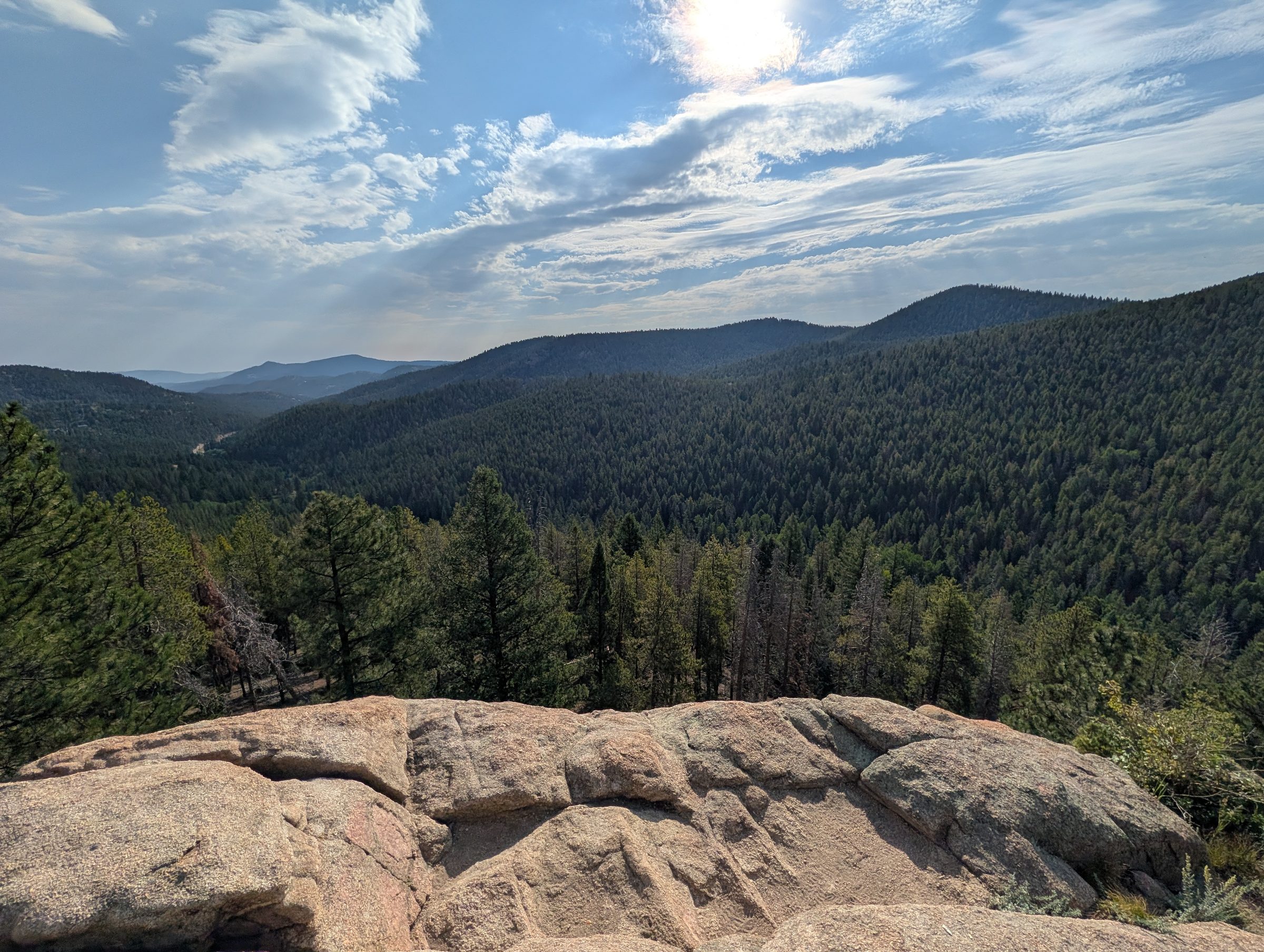
A wide view over forested hills and valleys from a flat granite outcrop under a bright sky.
The view from Meditation Rock on the Cliff Loop, the most reliable spot for cell signal in the area.

What the Cliff Loop is

On Forest Service maps it’s the Maxwell Falls Loop, trail #39.1. It runs 1.15 miles over the rocky ridge between two junctions on the main Maxwell Falls Trail: one just above the footbridge over Maxwell Creek, the other just above the falls. Add the stretch of main trail past the falls and you have a circuit of about 1.85 miles, waterfall on one side, outcrops and overlook on the other.

Some apps call this area the “Maxwell Bluffs.” Same loop.

The extra effort buys you granite outcrops and long views over the forested ridges toward Conifer. There are also fewer people up here than down at the falls. In late September you’ll catch some aspen color too.

Map © OpenStreetMap contributors. Trail signs are few: photograph the trailhead map before you start.

From the upper trailhead (2.4 miles)

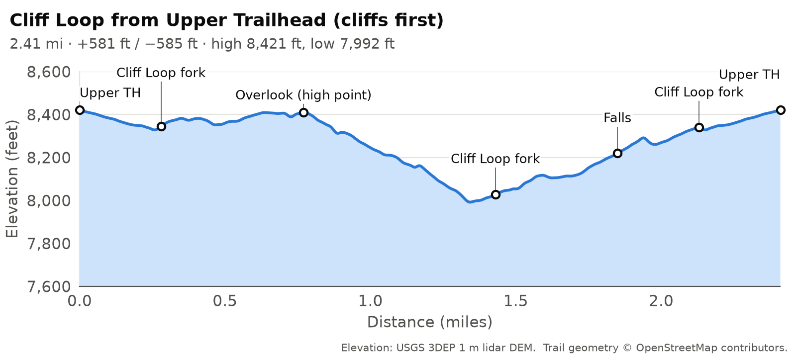
Most people do the loop from here. Distances below assume you go cliffs first.

Upper lot to the fork (0 to 0.28 mi)

Follow the connector from the lot past the old-road junction (about 0.18 mi) to the fork where the Cliff Loop leaves the main trail (about 0.28 mi). Keep left for the Cliff Loop. Right is the main trail, the direct way to the falls.

Along the west side (0.28 to 0.77 mi)

The loop climbs gently along the ridge. At about 0.56 mi an old, unsigned track branches off west toward Black Mountain Drive and the Cub Creek area. Stay on the loop. This is one of the places people most often drift onto social trails.

The high point and overlook (about 0.77 mi, about 8,410 ft)

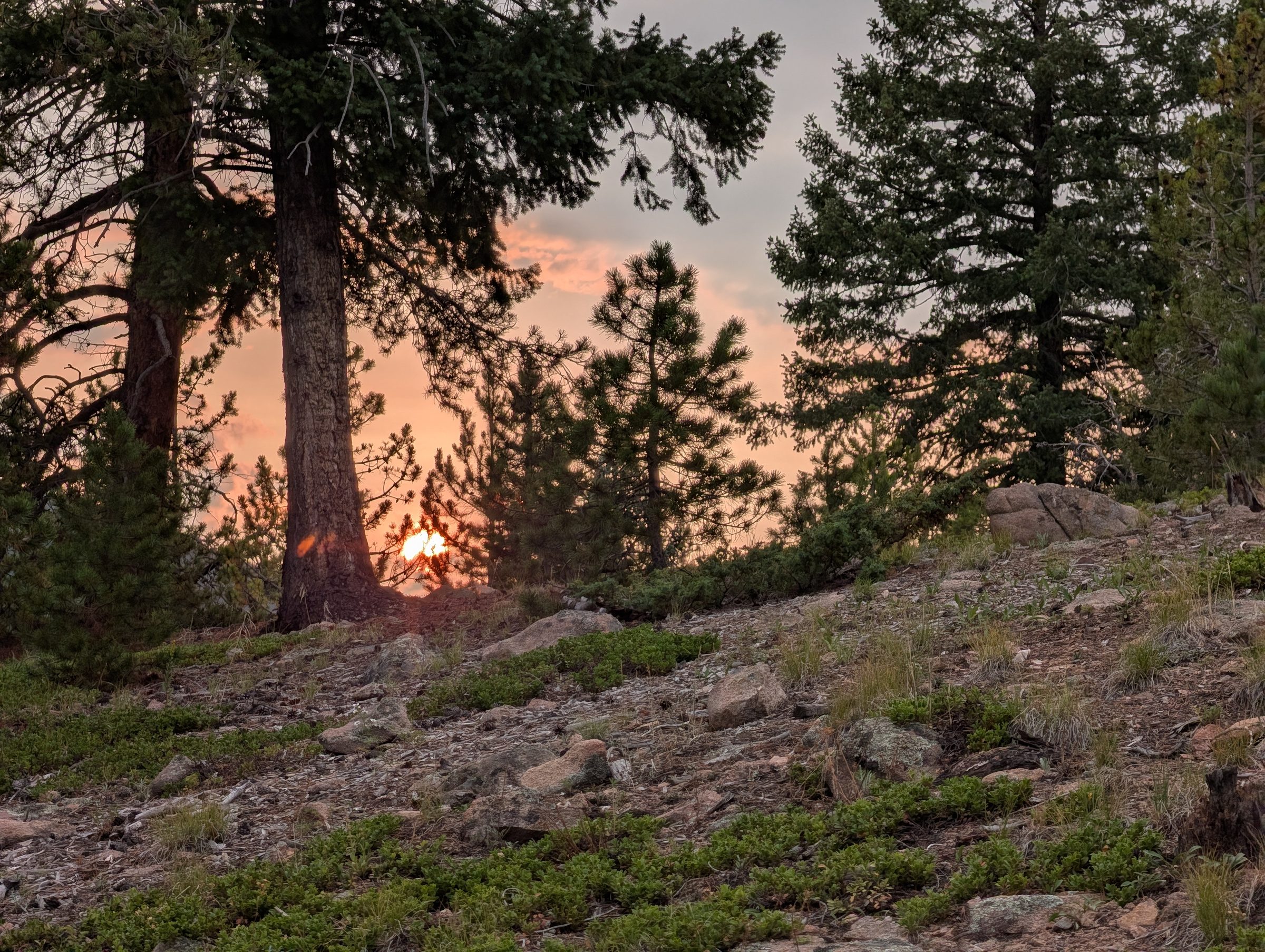
A red sun setting through wildfire smoke behind ponderosa pines on a rocky slope.
A smoke-reddened sunset from the high point of the Cliff Loop during wildfire season (August 2026).

The loop tops out among the rock outcrops, which is where the overlook is. The rock faces are steep and the drop-offs are real. Keep kids and dogs close and stay back from the edges.

The steep descent (about 0.8 to 1.4 mi)

From the high point the loop drops about 380 ft toward Maxwell Creek. It’s the steepest ground in the whole trail system, about 28% over short stretches, and usually loose gravel. Go slowly. Poles help if you have them.

Back along the creek, past the falls

At the bottom the loop meets the main trail near the footbridge. Turn toward the falls and follow the creek upstream about 0.4 mile to Maxwell Falls, then keep going up the main trail to the upper fork and back to the car. The last half mile is the same climb everyone does to reach the upper lot.

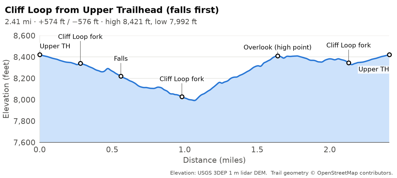
If you’d rather climb the steep part than come down it, go the other way. Take the main trail to the falls, continue down to the footbridge fork, then climb the loop over the cliffs back to the upper fork. Distance and climb come out nearly identical either way.

Elevation profile, Cliff Loop from Upper Trailhead (cliffs first): 2.41 miles, about 581 ft of climbing and 585 ft of descent, between 7,992 and 8,421 ft.
Cliff Loop from Upper Trailhead (cliffs first): 2.41 mi, +581 / -585 ft. Elevation: USGS 3DEP 1 m lidar; trail geometry © OpenStreetMap contributors.
Elevation profile, Cliff Loop from Upper Trailhead (falls first): 2.41 miles, about 574 ft of climbing and 576 ft of descent, between 7,992 and 8,421 ft.
Cliff Loop from Upper Trailhead (falls first): 2.41 mi, +574 / -576 ft. Elevation: USGS 3DEP 1 m lidar; trail geometry © OpenStreetMap contributors.

From the lower trailhead (4.5 miles)

From the lower lot the loop is a lollipop. You hike the main trail over the saddle to the footbridge (about 1.3 mi), go around the loop, and walk the same 1.3 miles back to the car. The Lower Maxwell Falls Trail guide covers that first stretch.

Which direction?

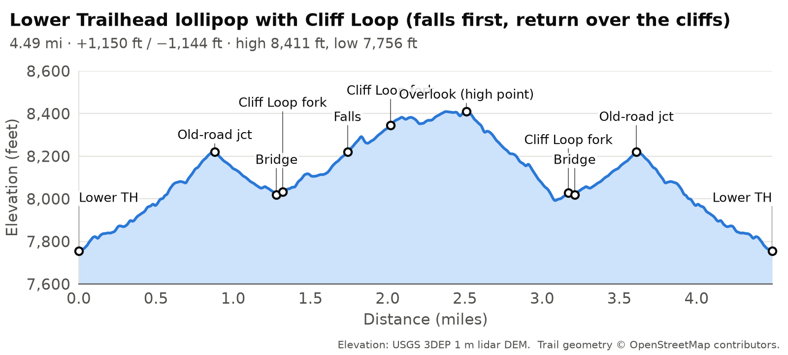
Falls first: at the fork just past the footbridge, go left along the creek to the falls (about 1.7 mi from the lot) and continue up the main trail to the upper fork (about 2.0 mi). Turn onto the Cliff Loop there, pass the high point, and descend the steep pitch back to the footbridge fork.

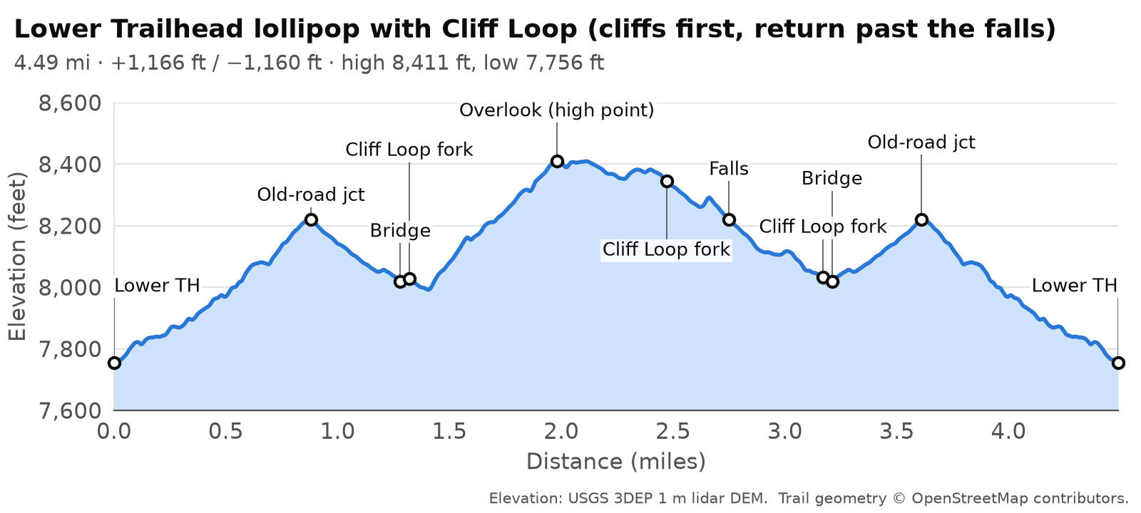
Cliffs first: at the same fork, go right and climb the loop. You hit the high point at about 2.0 mi from the lot. Carry on to the upper fork, walk down the main trail to the falls, and follow the creek back to the bridge.

Either way it’s about 4.5 miles and 1,150 ft of climbing. What changes is whether you go up or down the steep pitch on the cliff side. Cliffs first puts the climb early and saves the easy creek walk for the end, and a lot of hikers like it that way.

Elevation profile, Lower Trailhead lollipop with Cliff Loop (cliffs first, return past the falls): 4.49 miles, about 1166 ft of climbing and 1160 ft of descent, between 7,756 and 8,411 ft.
Lower Trailhead lollipop with Cliff Loop (cliffs first, return past the falls): 4.49 mi, +1,166 / -1,160 ft. Elevation: USGS 3DEP 1 m lidar; trail geometry © OpenStreetMap contributors.
Elevation profile, Lower Trailhead lollipop with Cliff Loop (falls first, return over the cliffs): 4.49 miles, about 1150 ft of climbing and 1144 ft of descent, between 7,756 and 8,411 ft.
Lower Trailhead lollipop with Cliff Loop (falls first, return over the cliffs): 4.49 mi, +1,150 / -1,144 ft. Elevation: USGS 3DEP 1 m lidar; trail geometry © OpenStreetMap contributors.

Wayfinding on the loop

Unofficial trails and junctions. Besides the official Forest Service trails, the Maxwell Falls area has many other trails, old roads and trail intersections that are not officially mapped or signed. It’s easy to take a wrong turn. Know in advance where you’re going, and store the trails on your phone or GPS device before you leave home so they work without a signal: download our GPX tracks and printable map, or save the area for offline use in the free COTREX app, Colorado’s official state trail map.

The loop has a reputation for confusing junctions, and it’s earned. Photograph the map at the trailhead before you set out, and download a GPX from this page or the map page, because cell data in the canyon comes and goes. Tell someone at home which trailhead you’re using, which direction you’re going and when you expect to be back.

Old roads and unsigned tracks cross the ridge, and several lead west toward Black Mountain Drive. None of them is the loop. The loop always comes back to the main trail at one of its two forks, near the footbridge or just above the falls, so if you reach the creek you’re back on the main trail.
Please don't walk the road between trailheads.

It’s 2.8 miles on Brook Forest Road and the connecting roads, with no sidewalk or shoulder along much of it, 25–30 mph traffic on blind curves, and spotty cell data. Hike out and back, set up a two-car shuttle, or pick a loop that returns to your own car. Why this matters

Phone signal and Meditation Rock

Cell signal is spotty in the Maxwell Creek canyon, and down by the creek even a 911 call may not connect. Locals get the best signal at Meditation Rock, the cliff area above the lower falls trail, and the Cliff Loop goes right past it. If you can’t get a call out from the main trail, climbing onto the loop’s higher ground is your best bet.

If a call fails, try a text. Jefferson County accepts Text to 911; put your location and what’s wrong in the first message. Mind the rock faces on the way up, and don’t leave an injured person alone if you can avoid it. Better still, leave a trip plan and download an offline map before you go, so you aren’t depending on signal in the first place.

More in Safety.

Downed trees

As of September 2026, no significant downed trees are blocking the Cliff Loop. Wind brought trees down around the area earlier in 2026, and a storm can drop more, so stay off any piles of downed timber near the cliff edges and don’t take your break under a leaning tree. Current conditions.

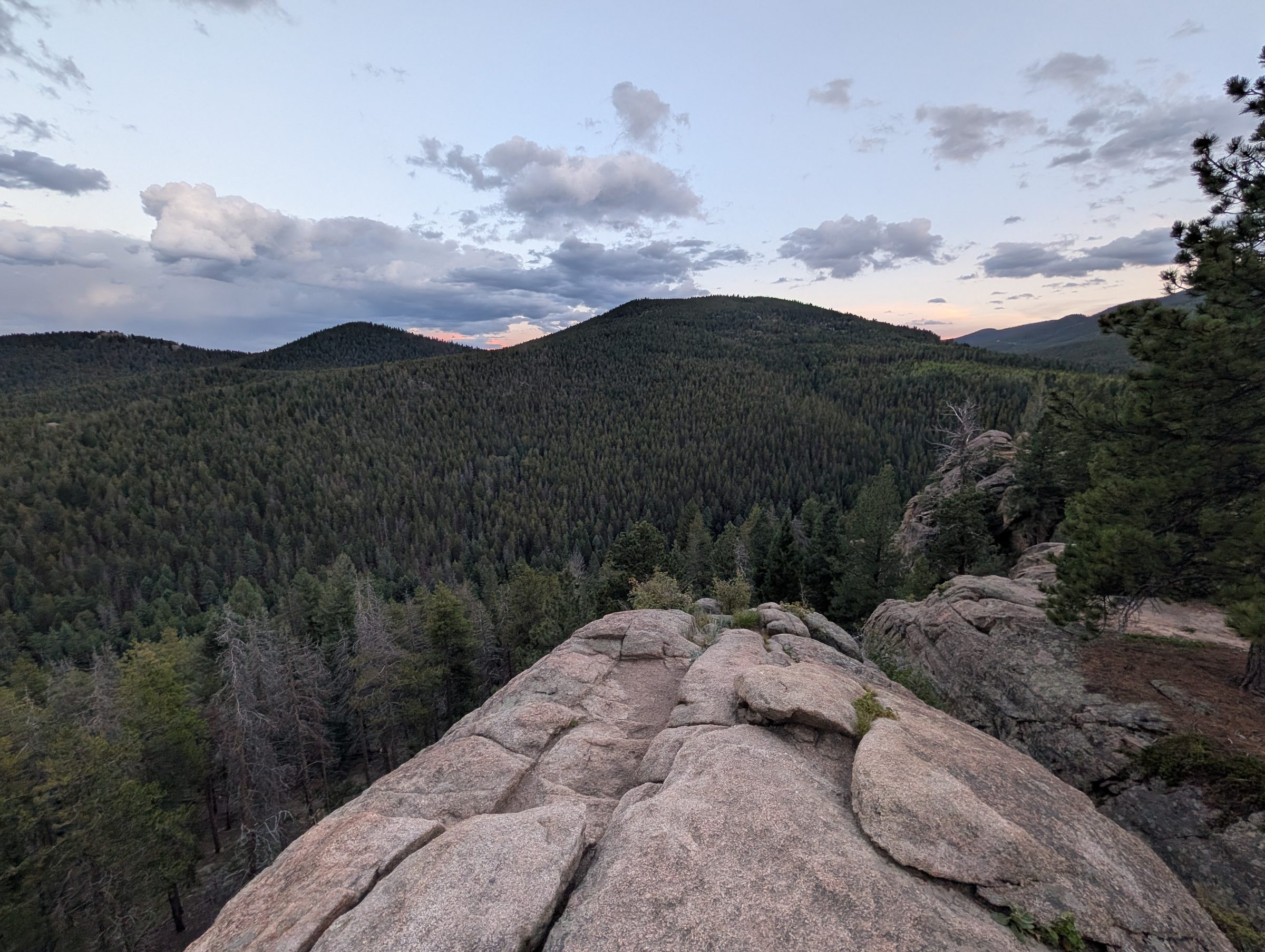
Evening clouds over rolling forested hills, seen from a broad granite outcrop.
Evening at Meditation Rock on the Cliff Loop (August 2026). The best spot in the area for cell signal.

Safety on the cliffs

The outcrops have steep faces and loose rock and soil, so stay on the trail and back from the edges. Dogs belong on a short, hand-held leash anywhere near them.

The ridge is also the most exposed part of the trail system when lightning is around. In summer, aim to be off the high ground by early afternoon, and turn back if you hear thunder. In winter the steep section can ice up, and microspikes make a big difference.

It’s quieter up here than on the creek trail, wildlife included. Stay on the trail. Neighbors have found mountain lion kills in off-trail parts of the area, and CPW advises keeping kids and pets close in lion country.

More in Safety.

How long is the Maxwell Falls Cliff Loop?

About 2.4 miles from the upper trailhead, or a 4.5-mile lollipop from the lower trailhead. The loop trail itself is about 1.15 miles.

Which direction should I hike the Cliff Loop?

Either works. If you'd rather climb the steep, loose section than descend it, go cliffs first from the lower trailhead, or falls first from the upper trailhead.

Is the Cliff Loop the same as the Maxwell Bluffs trail?

Apps use several names for this area. The signed Forest Service trail is the Maxwell Falls Loop, #39.1, which locals call the Cliff Loop.

Is the Cliff Loop safe for kids?

With supervision, yes. The trail itself is fine, but the outcrops near the overlook have real drop-offs. Keep kids close there.

Where can I get a phone signal near Maxwell Falls?

Signal is spotty, and even 911 may not connect by the creek. Locals find the best signal at Meditation Rock, the cliff area above the lower falls trail, reached by the Cliff Loop. Try texting 911 if a call fails.