
Maxwell Falls trail map
Day use only; no camping, fires or shooting. Current conditions
Interactive map
Map © OpenStreetMap contributors. Trail signs are few: photograph the trailhead map before you start.
The same area on aerial imagery
Imagery: USGS The National Map. Route lines © OpenStreetMap contributors.
The first map is the map view (OpenStreetMap). Right below it is the same area on aerial imagery (USGS). Tap a marker or a line for details. Both maps show:
- both trailheads and their lots;
- the Maxwell Falls Trail (#39; older listings say #111) between the trailheads;
- the Cliff Loop (#39.1);
- Maxwell Falls;
- the key junctions: the saddle and old-road crossing, the footbridge over Maxwell Creek, and both Cliff Loop forks.
Download before you go
The Forest Service trails aren’t the only paths out there. The Maxwell Falls area is laced with other trails, old roads and intersections that aren’t officially mapped or signed, and a wrong turn is easy. Decide where you’re going before you leave, and put the route on your phone or GPS at home so it works without a signal. Our GPX tracks and printable map are below.
For a phone map that works without signal, we recommend the free COTREX app (Colorado Trail Explorer), Colorado’s official state trail map. The Forest Service posts a COTREX “You are here” map with a QR code at the trailhead kiosks. Signal in the lot is too weak to count on for a download, so install the app at home, find Maxwell Falls and save the area for offline use while you still have a good connection.
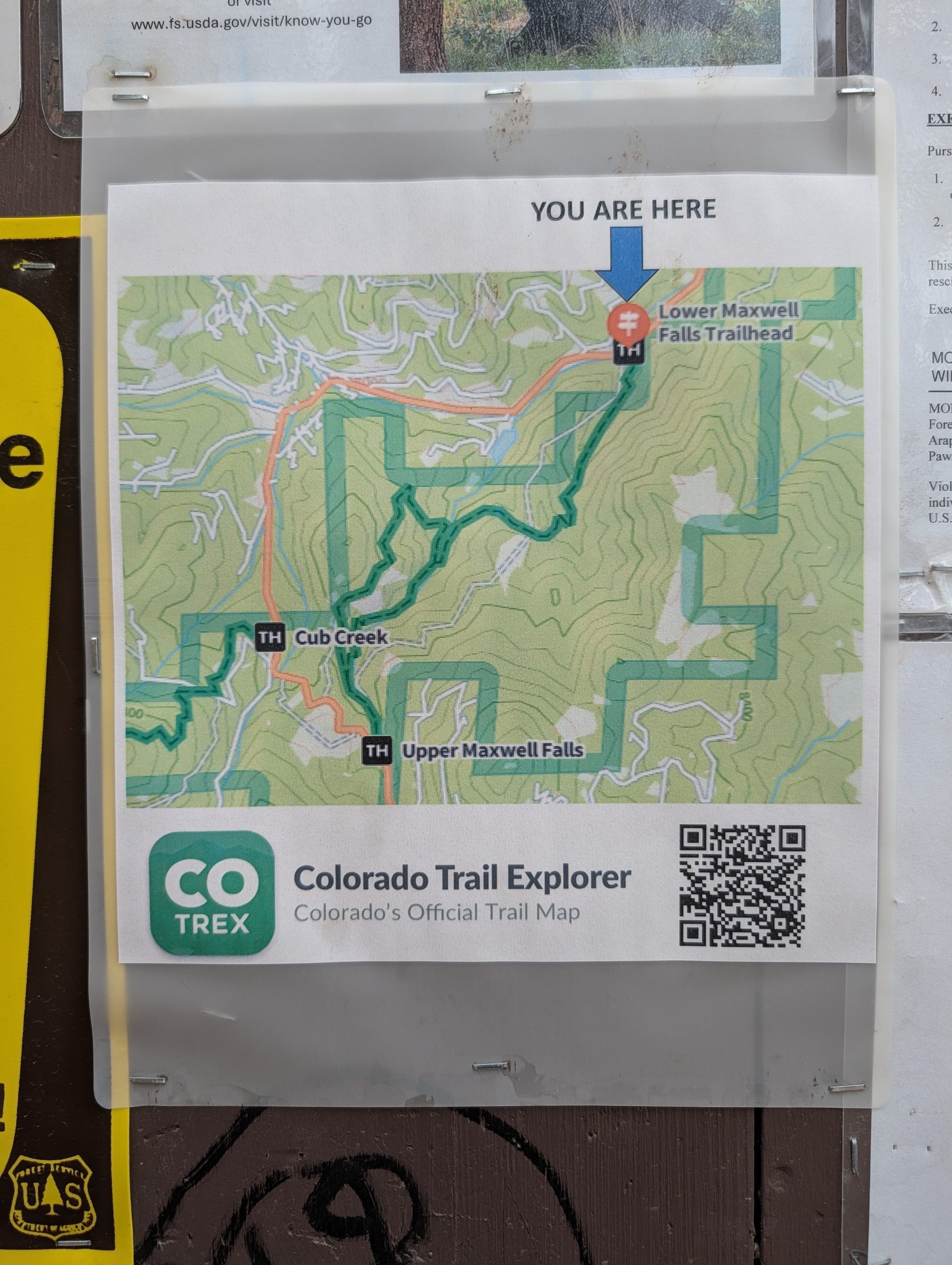
Cell data in the canyon is unreliable. Don’t count on loading a map once you’re on the trail.
GPX files for phones and GPS units:
| Route | Distance | GPX |
|---|---|---|
| Upper trailhead to the falls (out and back) | 1.1 mi RT | Download GPX |
| Lower trailhead to the falls (out and back) | 3.4 mi RT | Download GPX |
| Lower trailhead loop, cliffs first | 4.5 mi | Download GPX |
| Lower trailhead loop, falls first | 4.5 mi | Download GPX |
| Cliff Loop from upper trailhead, cliffs first | 2.4 mi | Download GPX |
| Cliff Loop from upper trailhead, falls first | 2.4 mi | Download GPX |
| Full trail, upper to lower (shuttle) | 2.25 mi | Download GPX |
| Full trail, lower to upper (shuttle) | 2.25 mi | Download GPX |
Most hiking apps will import a GPX file. They each recalculate the climb their own way, so don’t be surprised if yours doesn’t match our numbers. See how we measure.
Key points and coordinates
| Point | Latitude, longitude | Elevation | Distance |
|---|---|---|---|
| Lower trailhead | 39.58245, -105.36087 | About 7,750 ft | Start of the lower route |
| Saddle and old-road junction | 39.57353, -105.36683 | About 8,220 ft | 0.9 mi from the lower lot |
| Footbridge over Maxwell Creek | 39.57260, -105.37258 | About 8,020 ft | 1.3 mi from the lower lot |
| Cliff Loop fork, near the footbridge | 39.57286, -105.37290 | About 8,030 ft | 1.3 mi from the lower lot |
| Maxwell Falls | 39.56883, -105.37742 | About 8,180 ft | 1.7 mi from lower, 0.56 mi from upper |
| Cliff Loop fork, above the falls | 39.56599, -105.37852 | About 8,340 ft | 0.28 mi from the upper lot |
| Cliff Loop high point (overlook area) | 39.57184, -105.37645 | About 8,410 ft | 0.77 mi from upper, cliffs first |
| Upper trailhead | 39.56242, -105.37684 | About 8,420 ft | Start of the upper route |
The footbridge and overlook positions are our best estimate from map data. Nobody has checked them with a GPS on the ground yet.
Map cautions
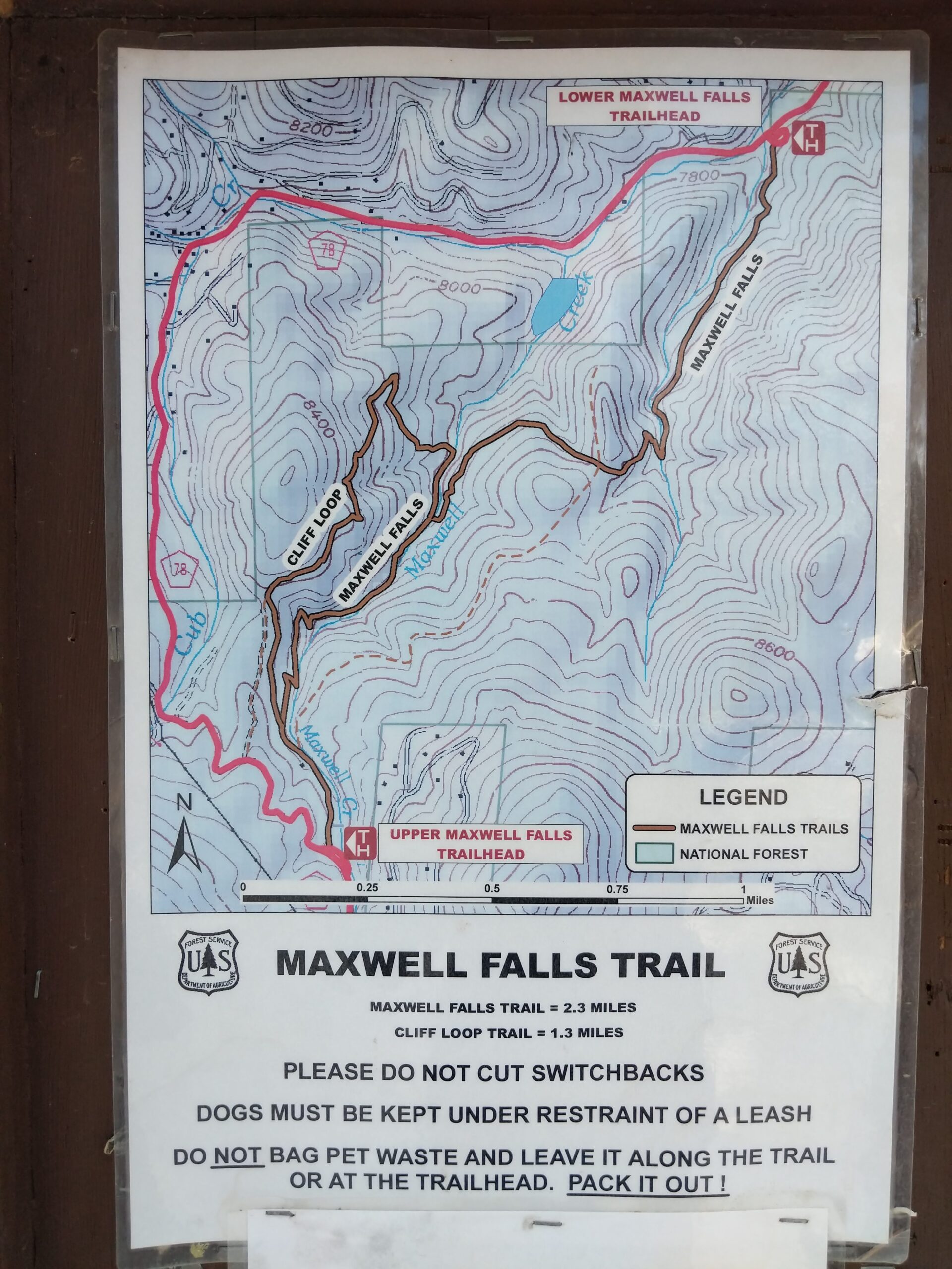
Two old four-wheel-drive roads run between the trailheads, roughly parallel to the trail, and they look a lot like trail. They aren’t the signed route. Stay on #39 and #39.1.
Unsigned tracks also branch west off the Cliff Loop toward Black Mountain Drive and the Cub Creek area, and people follow them by mistake all the time.
Each lot has a Forest Service map sign. Take a photo of it before you start.
Map data and credits
Measured by AlphaPixel for the Friends of Maxwell Falls. AlphaPixel built these map tools and did the GIS analysis, lidar measurements and route data behind every number on this site.
- Trail and road lines: © OpenStreetMap contributors, available under the Open Database License (ODbL). Our GPX files are derived from OpenStreetMap and are shared under the same license.
- Aerial imagery: USGS The National Map.
- Elevation: USGS 3D Elevation Program, 1-meter lidar.
- Map tiles come from our own mirror, so looking at this map doesn’t send your location to a third-party map service.
See a mistake on the map? Tell us. If the error is in OpenStreetMap, we’ll fix it there as well, and every app that uses OpenStreetMap picks up the correction.
Is there a printable Maxwell Falls trail map?
Yes. Download the PDF above, or take a photo of the Forest Service map sign at the trailhead kiosk.
Can I download the trail to my phone?
Yes. Every route has a free GPX file that most hiking apps can import, and the free COTREX app, Colorado's official trail map, can save the area for offline use. Do it before you leave home, because cell data in the canyon is unreliable.
Does the map show the parking lots?
Yes, both trailhead lots are marked. For directions and parking tips, see Trailheads and parking.
Sources
- OpenStreetMap contributors (ODbL)
- Map tools, GIS analysis and route data: AlphaPixel
- USGS The National Map (imagery) and 3D Elevation Program (1 m lidar DEM)
- COTREX: Maxwell Falls Trail and the COTREX app
- USFS: Lower Maxwell Falls Trailhead and Upper Maxwell Falls Trailhead